
Have your say
The Town of Port Hedland is shaping a bold future for two key urban areas the, South Hedland Town Centre and Port Hedland West End, through the development of new Precinct Structure Plans (PSPs).
These PSPs will establish a 10-year vision for how each precinct can grow into more vibrant, connected, and liveable places. They will guide land use, building form and density, infrastructure, movement networks, environmental values, and community spaces to ensure future development is well-planned and coordinated.
Community Consultation Phase 2 has now concluded, and we have moved into the development of draft Precinct Structure Plans for the South Hedland Town Centre and Port Hedland West End. You can now see the outcomes from Week 2 below:
Through Engagement Week 2 you, the community, reviewed and provided feedback on draft design scenarios. This feedback is now being carefully considered alongside technical studies, planning frameworks, environmental assessments and other evidence-based inputs to refine a preferred draft plan for each precinct.
FAQ - Phase 2
What happens next?
The planning team is currently using your feedback to:
- Refine key design directions
- Test access, movement and land-use ideas
- Embed cultural, environmental and place-based priorities
- Shape the draft Precinct Structure Plans that will guide future development over the next 10 years
There will be a final round of engagement when the draft PSPs are publicly advertised in mid-2026, providing the community with a formal opportunity to review and comment on the plans before they are finalised.
While formal consultation has now closed, we welcome informal feedback or questions during this stage of the project. If you would like to share thoughts or stay involved, please contact our Strategic Planning Team at:
📧 eplanning@porthedland.wa.gov.au
To keep up to date with project milestones and future engagement opportunities, click the "+ Follow" button in the top-left of the webpage to receive notifications about future updates on this project.
Thank you for being part of the journey as your input plays a vital role in shaping the final Precinct Structure Plans - so let's keep the conversation alive!
Why are we doing this?
Creating PSPs for the South Hedland Town Centre and Port Hedland West End will give us a clear, strategic plan for future land use and investment.
For the West End, the planning instrument ‘Improvement Scheme No. 1’ requires a PSP to be prepared to coordinate future development revitalisation. With fragmented land ownership in the area, a PSP can help set the development direction in a more coordinated way.
In South Hedland, the PSP will consolidate and modernise existing land use planning, replacing the current Structure Plan. It will serve as a catalyst for development and inform updates to the Town’s existing local planning framework.

Week 2 draft design ideas
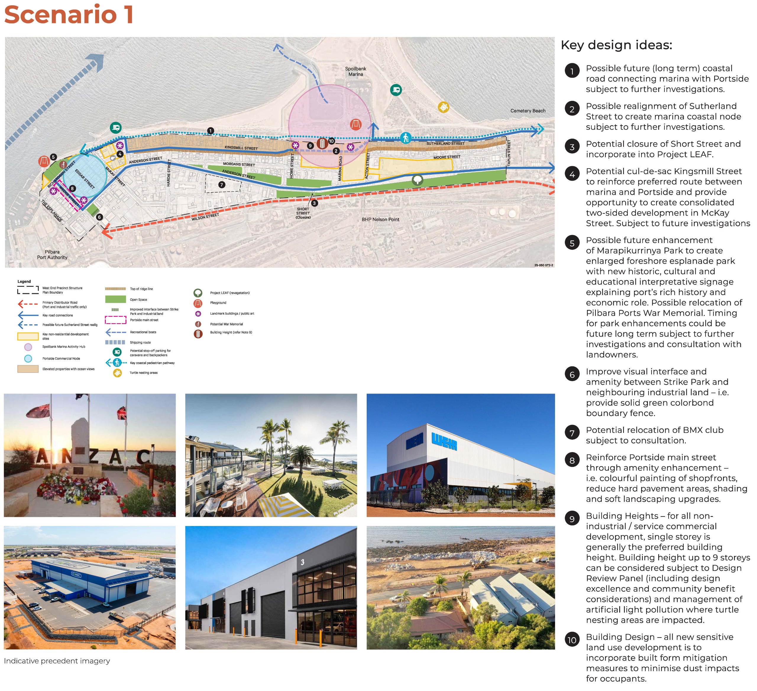
The scenarios for the West End aim to create an activity hub at the Spoilbank Marina, which could build on the investment in the area in different ways, each scenario framing the Spoilbank Marina as the heart of the West End, providing activity, new development and views out to the water. Wedge Street remains an important commercial node in the West End with proposed amenity enhancements (colourful painting of shopfronts, reducing hard paving areas, more shading and soft landscape upgrades). There is also the idea for future enhancement of Marapikurrinya Park to create a foreshore esplanade park with historical, cultural and educational signage.
Scenario 1
Scenario 1 looks at creating an Activity Hub at the Spoilbank Marina, which could build on the investment in the area to include more food and beverage offerings, short-stay accommodation and potentially uses like a visitors centre or conference centre.
To help facilitate this, it proposes a possible realignment of Sutherland Street to create this Activity Hub as a consolidated area with a pedestrian focus, rather than having a road run through the middle of it. This could also facilitate a possible future (long term) coastal road connecting the marina with Portside.
Access to West End for locals and tourists would be encouraged through McGregor Street, along Anderson St or Sutherland and Kingsmill Streets, whilst port traffic could continue along Wilson Street.
To view an enlarged version of the map, please click here.
Scenario 2
Scenario 2 also looks at creating an Activity Hub at the Spoilbank Marina.
Access to West End for locals and tourists would be encouraged through a new entry along Taplin Street, then along Anderson St or Sutherland and Kingsmill Streets, whilst port traffic could continue along Wilson Street after Taplin.
The overall scenario and more design ideas are depicted in the plan below:
To view an enlarged version of the map, please click here

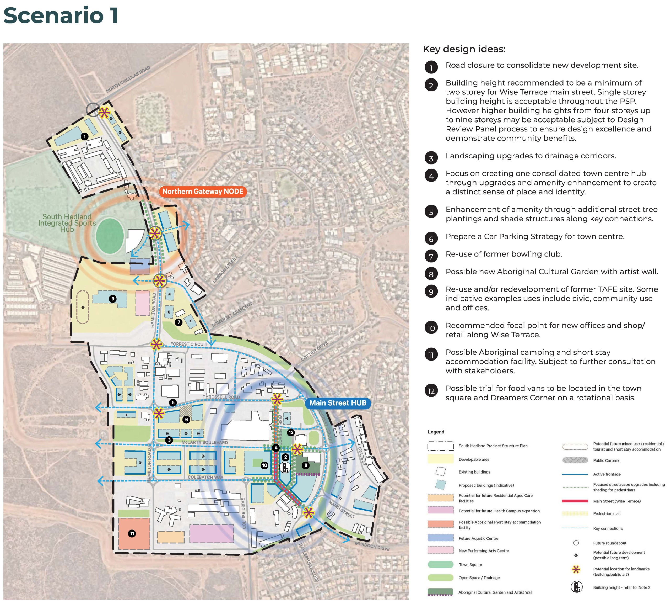
The scenarios for the South Hedland Town Centre precinct look at framing Wise Terrace would as the focal ‘main street’, with active frontages and streetscape upgrades including pedestrian shade, with a ‘town square’ between Wise Terrace and McLarty Boulevard. An Aboriginal Cultural Garden and artist wall would help upgrade the surrounds of the skate park.
Scenario 1
Scenario 1 looks at facilitating investment and enhancing the core of the South Hedland Town Centre, creating a consolidated ‘Main Street & Community Hub’ along Wise Terrace and the surrounding area with a distinct sense of place and identity.
Future development sites would help further define this heart of the Town Centre. The current minimum two storey building height requirement is reduced to single storey to encourage new development and increase activation of the town centre.
Scenario 1 is also supported by a ‘Northern Gateway Node’ near the South Hedland Integrated Sports Hub, acknowledging a secondary area of activity to the north of the Town Centre, with the relocated aquatic centre.
The overall scenario and more design ideas are depicted in the plan below:
To view an enlarged version of the map, please click here.
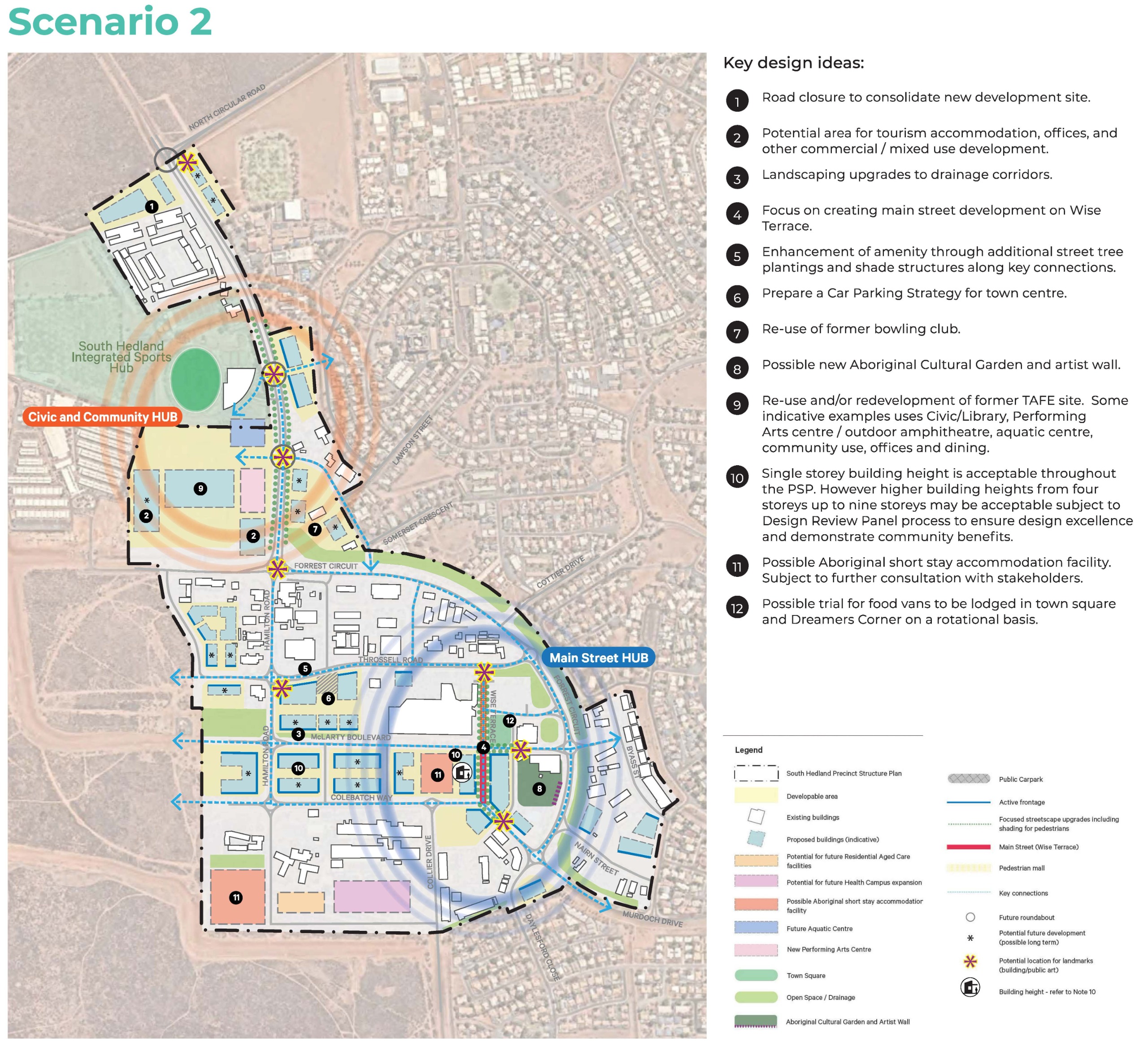
cenario 2
Scenario 2 also looks at a ‘Main Street Hub’ along Wise Terrace, and a ‘Civic and Community Hub’ to the north near the South Hedland Integrated Sports Hub and old TAFE site.
Future development sites would be focused along existing development sites and Wise Terrace. The current minimum two storey building height requirement is maintained – i.e. single storey development is not permitted.
The Civic and Community Hub would include the relocated aquatic centre, re-purposed TAFE site for civic and community uses, and improved connections across Hamilton Road.
The overall scenario and more design ideas are depicted in the plan below:
To view an enlarged version of the map, please click here.
PSP Boundaries
Image 1 of 2


